 |
| First 5 miles are rather barren |
WOW!! I have to say this road is probably the most diverse drive that I have been on. Very unusual geological formations and terrain.
I had not expected to be able to get all the way through the canyon, so I did not notate the mileage very well but I still think my descriptions will be helpful to you.
I was staying in Page, Arizona and spoke to the Rangers at the Big Water, Utah BLM office where they have some interesting information about dinosaurs and the rock layers of the Grand Staircase. One Ranger there advised me against doing the Cottonwood Canyon road with a low clearance vehicle. The other said that it was possible but that the road was washed out and closed 15 miles in. I decided to go in a few miles and check it out for myself.
The turnoff of Highway 89 for Cottonwood Canyon (Rd.400) is around mile marker 18. There was a big sign at the beginning that said that the road was closed 15 miles ahead, I ventured ahead anyway.
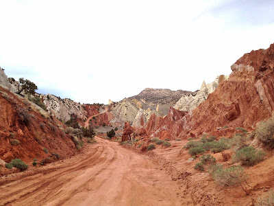
The road started out with a few small hills, then was basically flat, barren & boring. It was just gray shale without a lot of vegetation. I was tempted to turn around but saw a small bit of green ahead where it looked like the road might drop down to be more of a canyon so I decided to go at least 5 miles. At around 5 miles I could see the Paria river and that the road dropped down, remained soft and smooth so I continued. I wasn’t overly impressed with the river, but there was a little change in scenery and I could see some interesting pink, red and white rocks further down the canyon, so I kept going.
 |
| Paria River |
The road would go near the river, then wind up, around and through some unusual rock layers and formations. For the most part the road followed the power lines and was soft and level. Being out here with no other cars and going through a variety of different rock formations that you wouldn’t normally see made it seem a bit other worldly. When I hit the 15 mile mark, I expected that I would need to turn around but the road was fine so I kept going.
At around 19 miles in, I found where the road had been washed out but I also found a local rancher who was about to drive through the ‘closed section’. There were no road blocks or anything at this point it was just muddy. I talked to the Rancher who told me that this 200 or so foot section was the only bad part of the road all the way to Cannonville. He thought I would be able to make it through this section if I used my 4WD and that if I didn’t he would pull me out with his truck. I pondered a moment then went for it and I am glad that I did! I think the most beautiful parts of the road were beyond this section.
 |
| Washed out section |
There were some red, white and pinks on the road prior to this but the canyon becomes a little narrower and the rock formations just seem more dramatic. They were several hiking trials going forward, two at ‘the Narrows’ which appeared to be slot canyonish and being there was a chance of rain and I had not planned on coming this far and wasn’t sure how long it was going to take me to get back to Page, I did not explore them.
 |
| Kinda looks like a tilted pizza! |
 |
| Vertical white uplifts rt side, pink, white & reds on left |
 |
| Funky! - Apparently called a Cockscomb Feature |
 |
| Kind of a Bryce Canyon & Zion mix |
 |
| Grosvenor Arch |
 |
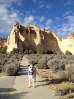
| Golda the Adventure Dog |
I did stop at Grosvenor Arch, which was pretty cool. The turnoff for the arch was around mile 29. It is a quick jot down the the arch were there is a parking area and signage. The Cottonwood Canyon road at this point gets out of the weird rock layers and is more open sage brush type terrain with wide sweeping views. The vegetation gradually increases and changes to bushes and pinyon pines until you drop down to pavement. Once you hit pavement, Kodachrome State Park is too the right and well worth the side trip. It was getting close to sunset by the time that I got here and the light rays on the colored rocks were awesome. I would have liked to stayed and explored a bit longer.
The quickest way back to Page would have probably been the Cottonwood Canyon road but since I didn’t want to attempt the washed out section alone and possibly in the dark, I chose to take Skutumpah Road (Rd. #500) to Johnson Canyon Rd to Highway 89 to get back. This road comes in before you get to Cannonville, so I did not make it there. The Rangers had suggested I take this route to go see Kodachrome. I actually found the north side of this route much more rutted than anything on the Cottonwood Canyon Road. There are some high points on the north end of this road that give you nice views back towards Kodachrome. The southern end of Skutumpah is just gravel and this route when dry is fine for a low clearance vehicle.
 |
| Terrain change before you get to Kodachrome |
 |
| Kodachrome State Park |
 |
| Kodachrome State Park |
Overall, the Cottonwood Canyon road was very unique and I would do it again. The road was fine for a passenger cars as long as it is dry. I would not have attempted going through the washed out area of the road without 4 wheel drive and someone with a big truck and chains to pull me out present. I did this route in late April. I expect the road will dry out at some point and they will take down the signs. If you are on the north side near Cannonville, the road is worth the drive down towards the Narrows and where the washout occurs. I would definitely plan on making stops at Grosvenor Arch and Kodachrome State Park while in this area.


1 comment:
Wow!!! Beautiful photos. Congrats on making it through the washed out section! It definitely would have made me turn around.
Post a Comment